My son Shoon and I had been thinking about climbing Franconia Ridge this year, and we finally got our chance (and more than we expected) in late July 2010 when a large cold front pushed through the Eastern USA. Here is the story of our adventure.
NOTE that you can see the video to accompany this blog (either now or later) if you click on... YouTube - Franconia Ridge NH July 25-26, 2010 v2.mov (noise from strong wind)
NOTE that you can see the video to accompany this blog (either now or later) if you click on... YouTube - Franconia Ridge NH July 25-26, 2010 v2.mov (noise from strong wind)
OUR STORY:
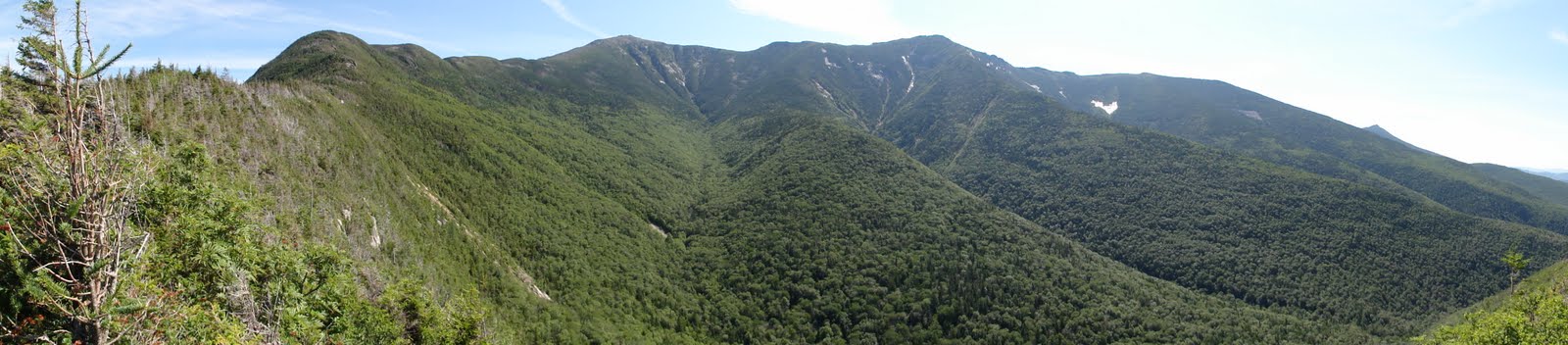
The panoramic photo above shows the Franconia Ridge in a tranquil mood on July 27th "The Morning After", but throughout July 26th the weather was wild, cold and very windy on top of the ridge (much colder than the forecast we used for planning the hike, about 70 degrees as predicted by TheWeatherChannel for Franconia Notch State Park). We later saw the official Franconia Ridge weather report, as in the image below, and note the Temp and Wind for the summits Today (July 26th)... Temp: Mid 40's and Winds: NW 60-80mph and 50-70mph in the pm (and these were steady winds, not even the gusts) with WindChill of 20-30degrees F! Amazingly cold windy weather for late July, since that 4th week in July has averaged out to be the hottest week of the year in the NorthEast during the last hundred years.....
 |
| The official Franconia Ridge weather report for Monday July 26, 2010 as seen after our climb |
This is a true story about two hikers who struggled with that wild weather on July 26th as they ascended to that exposed ridge, crossed it slowly (after a leg injury) for two cold miles, ran out of time, and searched for a safe place to pass the night.
Late last year my son (14 at the time) and I decided we wanted to climb one of the top ten peaks in the Northeast USA. We wanted to find a challenging and risky goal near home, one that required our hard work. We wanted to push ourselves to conquer that goal. We focused on the more difficult short hikes in the White Mountains of New Hampshire, and selected the 9-mile loop at Franconia Ridge. We had climbed similar peaks elsewhere, but nothing this close to home. We were hoping to enjoy one of the best mountain experiences on the East Coast. We knew that the East Coast mountains are much shorter than those in the West, in Alaska or in other mountainous countries, but we were hoping to find the strongest taste of Wilderness within driving distance of our Connecticut home. We wanted to see Nature at its best, locally, and we hoped for an excellent outdoors day to be remembered for a lifetime. Thankfully, we found all this and more.
A large cold front pushed through the Northeast on July 25th, and we decided we'd drive into the White Mountains, up to Franconia, New Hampshire that day and climb up to the ridge the following morning. It had been so hot in July, up around 100 degrees F, however, that we feared it would still be too hot and humid up there for an exciting climb on July 26th. We were so wrong!
The purpose of this blog post is to share (with family and a few friends) some aspects of the very pleasurable day we had at Franconia Ridge, NH. And to try to put some of this experience into a "bottle", so that next January when we are stuck (inside) by a blizzard (outside) we can open this "bottle" and re-experience some of July 26, 2010! So it is partly our diary, written for us. Feel free to skip any sections of text which are not of interest. We hope you enjoy this.
SUNDAY EVENING
Shoon (my 15 year old son) and I packed and left home around 6pm on Sunday July 25, 2010. It took us almost 4 hours to drive up i91, take exit 17 in Vermont, and cut across eastward to our motel in Franconia, NH.
 |
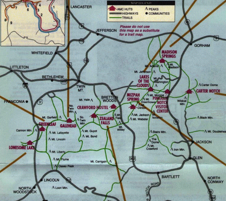
| The White Mountains, in the northern third of New Hampshire. Mt. Lafayette on the Franconia Ridge is about 8 miles north of Lincoln (see Inset A). Click on map to expand, and then stretch it. |
Coming down Sugar Hill Road (NH route 117) around 10pm, approaching Franconia we could see the large Franconia Ridge under a bright moon, entirely wrapped in a thick looking blanket of clouds, even though there were no other clouds anywhere in the bright night sky. It seemed to be a strange weather phenomenon to us, perhaps suggesting the weather surprises to come, and warning us that the weather atop that 5,000 foot ridge can be extremely different from the weather down at the 1,700 foot trailhead parking lot. Having studied the weather maps, we knew there would be no rain or thunderstorms, but we underestimated the wind!
MONDAY MORNING
Our Hillwinds Lodge motel was clean and free of bugs. We had gotten a good nights sleep, which is important for climbing, at least for my old legs. Continental breakfast included english muffins, danish, and coffee, plus some ham sandwiches which we had brought with us.
In ten more minutes we were at the "Franconia Place" parking lot. We drank more water and fruit juice, and then we walked 5 minutes to the trailhead on the east side of the I-93 highway, and began our climb around 10am.
We walked southeast for 5 minutes and had to choose either the Old Bridle Path on the left, or the steeper Falling Waters Trail on the right. Either way, this "Franconia Ridge Loop" would take us about 9 miles, including some pretty strenuous hiking. We selected the 3.0 mile Falling Waters Trail to take us up to the 4,761 foot Little Haystack Mountain summit, on the southern section of the Franconia Ridge. Note that there is no ski lift, aerial tramway, gondola or anything like that along the Franconia Ridge....its just old-fashioned hiking on two legs.
Here is the map of that 9-mile loop, and, as with all the other photographs here, you can left click or right click on it, and then greatly expand it on screen, e.g., by dragging the lower right corner (or right side) to the right...
Here is the map of that 9-mile loop, and, as with all the other photographs here, you can left click or right click on it, and then greatly expand it on screen, e.g., by dragging the lower right corner (or right side) to the right...
 |
| The 9-mile Franconia Ridge Loop which we hiked, starting from the lower left, going counter clockwise |
 |
| Another map of the 9-mile loop... this one from... www.hikenewengland.com |
We started our ascent, crossing Walker Brook and then Dry Book several times, including one place where it was not obvious which way to go.... there was no sign, but there should have been one. Almost two hours later we had to scale the steep 80-foot Cloudland Falls waterfall (Cloudland Falls), climbing on rocks just off to the left side of the cascading water. Near the top we had to hug the rocks and grab them with our hands to pull ourselves up. I had no idea if I would be able to come back down this way safely! How, by backing down, using the same handholds? And if we had to do it in the dark, with headlamps, where you reduce some of your equilibrium/balance, it would have been risking a dangerous fall.
Shortly after this I pulled a deep muscle in my upper left leg, leading to a cramp there, making a retreat back down this path essentially impossible. Based on all this we decided it would not be safe to come back this way, even if we wanted to, and that we had no choice but to push on to the top of Little Haystack mountain, then across the exposed two-mile Franconia Ridge trail, scaling both Mt. Lincoln (5,089 feet) and Mt. Lafayette (5,261 feet), and then coming back down 1.1 miles via the Greenleaf Trail and then almost 3 miles on the Old Bridal Path. So we pushed on, up toward the 4,761foot summit of Little Haystack.
I was basically out-of-shape, and had my lung capacity reduced by pneumonia 2 years ago, so I had to stop frequently for 30 second periods to catch my breath, and sometimes drink a few sips of water. Shoon and I used Leki anti-shock hiking sticks, and they helped throughout most of the climb and descent, but in the steepest places they were useless. Shoon did fine with low shoes, but I was afraid of twisting my ankle on the zillions of boulders on the trails, and wore higher Vasque Breeze GTX boots, which worked out great, although I was wary of their bad reputation on wet slippery rocks. Eventually I did slip as a rock rolled out from under me, and twisted my ankle.
We resumed our strenuous climb upwards, and as we climbed higher the trees around us got shorter in height, as the effects of the year-round winds showed on the spruce-fir forest. As we approached the summit the winds sounded stronger and stronger. We were in the trees until just before the summit. Our anticipation grew. Finally we emerged above the tree-line and found ourselves within 50 feet of the summit of Little Haystack, with suddenly spectacular views, but blasted by fierce winds at 60, 70 and more miles per hour. We pulled up our windbreakers' hoods, tightened the straps, and shielded ourselves from the roaring wind by crouching behind giant rocks. We moved to the leeward side of the summit, behind the mass of the promontory, and had our breath taken away by the spectacular views spread out before us in every direction. The gigantic ancient volcanic caldera now called the Pemigewasset Wilderness opened up in front of us. Twenty miles East of us Mt. Washington's summit stuck up into the rapidly moving broken cloud layer. White and gray clouds also flew over our heads several hundred feet up, while their shadows raced across us and the green forests below.
The Dartmouth College website referenced below describes this area:
The other-worldly feeling on this ridge may also be partly because this ridge is unusual treeless habitat, true and rare Alpine Tundra habitat, seen in the East in only two places: 1) the tallest summits and ridges of New Hampshire's White Mountains (such as Franconia Ridge and Mt. Washington) and 2) the summit of Maine's Mt. Katahdin, above 4,500 feet, above the tree line. These are remnant patches of true northern Arctic Tundra, stranded at these high altitudes when the glaciers retreated ages ago, and populated by more northern plant, bird, insect, fungal, protozoan and microbial species .....
I wanted to concentrate on the scenic views, to study them, and lock them into my brain for future enjoyment, but they were overwhelming, and I couldn't process them the way I planned to. The views were spectacular around a full 360 degrees. Near and far the mountains and colors were fascinating. The wind was roaring, knocking us around, while the clouds flew over us at high speed. It was extremely intense, much more than I had expected. In retrospect I think the unlimited views, the temperature, the clouds zooming over us, and the gusting wind were all overloading our senses in a way that we rarely encounter in every-day life.
The Dartmouth College website referenced below describes this area:
"The north-south ridge [Franconia Ridge] ... is the western flank of an old volcano. Similar to Crater Lake in Oregon, this volcano spewed out so much of its interior ash and lava that it eventually collapsed into itself. The ensuing basin is known geologically as a caldera, and this one stretches [about 8 miles] across the Pemigewasset Wilderness to where the Twins and Bonds form the eastern flank. The rock that is now exposed as the Franconia Ridge is a granite that during the time of the volcanic eruptions was still liquid magma far below the surface. In the ensuing hundred million years, water and ice have eroded away all of the volcano that once towered many thousand feet above today’s Little Haystack [where we are now standing, in the wind]."There was nothing in my mind but this, this spectacle of Nature, the glory and the power of this, while we were just clinging onto this ancient mountaintop, trying not to get blown off. This was a lot more spectacular, and colder, than we had expected. We felt like we were in Heaven, a cold windy Heaven formed a hundred million years ago when this huge volcano erupted massively.
The other-worldly feeling on this ridge may also be partly because this ridge is unusual treeless habitat, true and rare Alpine Tundra habitat, seen in the East in only two places: 1) the tallest summits and ridges of New Hampshire's White Mountains (such as Franconia Ridge and Mt. Washington) and 2) the summit of Maine's Mt. Katahdin, above 4,500 feet, above the tree line. These are remnant patches of true northern Arctic Tundra, stranded at these high altitudes when the glaciers retreated ages ago, and populated by more northern plant, bird, insect, fungal, protozoan and microbial species .....
 |
| Habitat map from Rick Cech and Guy Tudor, 2005. See pages 6-17 of their excellent book for definitions.. |
I wanted to concentrate on the scenic views, to study them, and lock them into my brain for future enjoyment, but they were overwhelming, and I couldn't process them the way I planned to. The views were spectacular around a full 360 degrees. Near and far the mountains and colors were fascinating. The wind was roaring, knocking us around, while the clouds flew over us at high speed. It was extremely intense, much more than I had expected. In retrospect I think the unlimited views, the temperature, the clouds zooming over us, and the gusting wind were all overloading our senses in a way that we rarely encounter in every-day life.
Hiking this particular ridge is what we had dreamed of during the winter. But in reality it was more spectacular than all the photographs put together. It was not the mountains of Alaska or the Western USA, or the Eiger in the Swiss Alps, but experienced hikers have said that this is about as good as it gets in the Eastern USA. I have been on much higher mountains, with spectacular views, but there is something very special about Franconia Ridge, and hiking those two exposed miles along the "knife-edge" ridge, as it is called. For me it was a memorable lifetime experience that I cannot fully describe in words, although I am trying to capture some of the feeling in this blog. Hopefully it will be something my son remembers positively for a long time also. I confess that is one of the reasons I created this blog describing our shared experiences that day, for my son to remember, and for the rest of our family to be able to share some of this.
MONDAY AFTERNOON
Finally on top of the ridge, and dazed by the beauty, we couldn't move for about 15 minutes. Two slate-colored Juncos struggled with the wind to get in and out of their nest in the fir trees 20 feet below the summit, shielded on the leeward side. We ate a few granola bars, drank some water, pulled away our wind-breaker hoods so we could absorb and enjoy the full windy experience, and then set off on a never-to-be-forgotten trek across this two-mile exposed section of the other-worldly Franconia Ridge.
We videotaped parts of this two mile hike across the ridge, and you can see nine minutes of it on YouTube by clicking on this....
 |
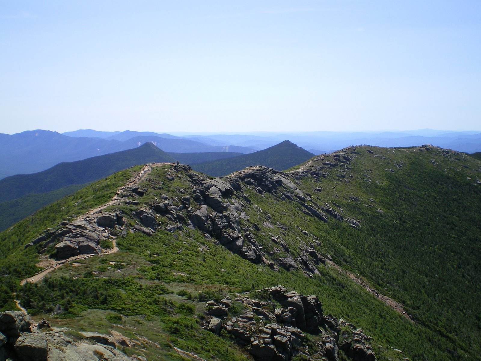
| Hiking the ridge toward Mt. Lincoln at 5,000 ft altitude. Note several hikers (little dots) on the ridge about 1/10th of the way to Mt. Lincoln. |
We videotaped parts of this two mile hike across the ridge, and you can see nine minutes of it on YouTube by clicking on this....
YouTube - Franconia Ridge NH July 25-26, 2010 v2.mov
Please look at this video to get a better feeling for the weather on top of the ridge, and the scale of the mountains along the ridge.
Please look at this video to get a better feeling for the weather on top of the ridge, and the scale of the mountains along the ridge.
We hiked almost a mile from Little Haystack to Mt. Lincoln's summit, across a ridge trail that was being blasted by high-speed wind, trying to push us literally off the mountain, and there were several places along this ridge trail where careless hikers could fall off or be blown off, down hundreds of feet or more. It was so windy that almost no other hikers ventured across the ridge line that afternoon, so we were mostly alone. Fortunately the Franconia Ridge path is generally wider than the true knife-edge ridge approach to Mt. Katahdin's summit, where 19 people have died in recent decades, and we traversed this ridge with maximum caution on this windy day.
Nevertheless, the views on both sides of the ridge trail were spectacular. I took out my video camera a few times, only to have the wind shake it so violently that the video pictures look very unsteady and jerky, regardless of how hard I tried to stabilize the camera.
 |
| Obstacles on the approach to the Mt. Lincoln summit. Notice the hiker climbing in the foreground. |
Nevertheless, the views on both sides of the ridge trail were spectacular. I took out my video camera a few times, only to have the wind shake it so violently that the video pictures look very unsteady and jerky, regardless of how hard I tried to stabilize the camera.
 |
| Looking down at the wind-stunted "Krummholz" vegetation, and the long drop down from this western side of the Franconia Ridge "knife edge" |
This entire ridge trail is at about 5,000 feet altitude, and more than 3,500 feet above the trailhead parking lot below. We had climbed that 3,500 feet, almost three times the height of the original World Trade Center. A few short sections of interstate I-93 were visible far below, with a few cars moving along it like tiny dots, but 99% of the view was of green wilderness and mountains all around. We walked the first section of the ridge for more than an hour to get to the Mt. Lincoln summit, with plenty of climbing required, including some passages near to some steep drops. One thing for sure, we were up pretty high, with no quick or easy way back down to the bottom of these mountains.
Mt. Lincoln blocked our view of Mt. Lafayette for an hour. As we got to the top of Mt. Lincoln we were very surprised to see the greater height of Mt. Lafayette looming another mile up ahead of us along the ridge. It appeared higher than we expected, and it was already 4pm, thanks to my injured left leg which had slowed us down. The winds continued very strong, and we stopped behind a mass of rocks to discuss the situation, and the low probability that I could hike fast enough for us to get off the mountain and back to the car by the time darkness would set in, a little after 8pm. We had LED headlamps, but we were not sure how difficult it would be to hike down the boulder-strewn trails in total darkness, and be able to stay on the correct trail, even with those bright lamps, and the reserve batteries we carried.
 |
| Some of the obstacles on the way up to Mt. Lincoln, and the Krummholz-form Black Spruce and Balsam Fir on this protected leeward side of the ridge. |
Mt. Lincoln blocked our view of Mt. Lafayette for an hour. As we got to the top of Mt. Lincoln we were very surprised to see the greater height of Mt. Lafayette looming another mile up ahead of us along the ridge. It appeared higher than we expected, and it was already 4pm, thanks to my injured left leg which had slowed us down. The winds continued very strong, and we stopped behind a mass of rocks to discuss the situation, and the low probability that I could hike fast enough for us to get off the mountain and back to the car by the time darkness would set in, a little after 8pm. We had LED headlamps, but we were not sure how difficult it would be to hike down the boulder-strewn trails in total darkness, and be able to stay on the correct trail, even with those bright lamps, and the reserve batteries we carried.
We contemplated several alternatives, all of which required us to first hike another mile up the ridge to the top of Mt. Lafayette, in this battering wind, and then hike down the other side, on the Greenleaf Trail through a half-mile field of large boulders. One alternative was to hike all the way down the mountain in the dark, slowly and carefully, but I was getting exhausted and slowing down from having to protect my sprained left leg so much, so this seemed very difficult to accomplish. The second alternative was to sleep on the ground in some protected area of the mountain, preferably well below the treeline. The third alternative was to get to the Greenleaf Hut, about a mile hike down from the Mt. Lafayette summit and ask them if we could stay there, even though we did not have a reservation.
We had been planning on the first alternative, to hike all the way down that afternoon, but my left leg unexpectedly slowed us down so much that this alternative was becoming impossible. We decided to go to the Greenleaf Hut, exhausted and now hungry, and ask them to let us stay there, one way or another. This mountain hut had been in our plans only as a last ditch backup alternative in case of any trouble, and we had not made any reservations, so there was a chance, we thought, that the only thing they could offer us might be sleeping on the floor in the kitchen.... but sleeping on the floor inside a hut began to seem like a relatively good outcome, compared to sleeping outdoors on that windy night. But first we had to "bag" Mt. Lafayette, to get up and over this huge obstacle (Mt. Lafayette) which stood in our way. (-:
MONDAY EVENING
We dragged our way across the next mile of ridge, descending about 200 feet and then climbing another 500 feet, steeper and steeper, finally topping Lafayette around 6pm, with the wind as strong as before. We were joined by two Ravens who battled the wind, landed on the summit, and then were blown off, sailing away on big black wings.
.
.
We then headed down through a half-mile field of large and medium boulders, and then into a half-mile of short evergreens.
My left leg had gotten worse, and I could barely make progress, even though the trail flattened out as we approached the hut.
We arrived at the hut exhausted, climbed the steps, walked into the main room, over to the desk, and just asked if they could accept two more people for the night. The man asked if we had reservations, and I said no, expecting the worst. He spoke with another person, and after what felt like a long time, came back and said, "I think we have two open bunks... Find them in the room on the left side, put your stuff on the bunks, and come back to join us for the end of dinner!"
 |
| Finally on top of Mt. Lafayette, looking northeast across the huge caldera, with Mt. Washington touching the clouds almost 20 miles in the distance |
.
 |
| The signs on the summit of Mt. Lafayette |
.
 |
| The wind blasting across the summit of Mt. Lafayette, making it difficult for the photographer (me) to get a steady shot! |
We then headed down through a half-mile field of large and medium boulders, and then into a half-mile of short evergreens.
 |
| Facing the wind, in the alpine tundra rock field, heading down toward the Greenleaf Hut which is at 4,200 feet altitude, on a shoulder of Mt. Lafayette, and not visible from lower altitudes or I-93 |
My left leg had gotten worse, and I could barely make progress, even though the trail flattened out as we approached the hut.
 |
| Approaching the hut through a forest of low evergreens and an easier horizontal trail |
We arrived at the hut exhausted, climbed the steps, walked into the main room, over to the desk, and just asked if they could accept two more people for the night. The man asked if we had reservations, and I said no, expecting the worst. He spoke with another person, and after what felt like a long time, came back and said, "I think we have two open bunks... Find them in the room on the left side, put your stuff on the bunks, and come back to join us for the end of dinner!"
Shoon and I looked at each other, and gave a sigh of relief and pleasure! I joked about being lucky to find a hotel and restaurant at 4,200 feet altitude, and the staff guy laughed. We thanked the staff member several times, and ran in to find the last two empty bunks. We took one bunk on the second level, and one on the third level, and put our stuff on them.
Shoon said he was too tired to eat and climbed up to his bunk. I went out to eat dinner in the dining room. I joined the staff who was eating together after the thirty guests had finished their dinner. One of the staff asked where is Shoon, and after I explained he was too tired to eat she said No, he had to eat, especially the soup to restore his salt for the muscles, and that she would go and get him out of bed! I smiled, and just enjoyed another one of the good things about human nature. Sometimes I think we are "pack animals", like wolves, and on July 26th we were just welcomed into this new pack.
 |
| The bunk bed up at the second level, in the Greenleaf Hut |
Shoon said he was too tired to eat and climbed up to his bunk. I went out to eat dinner in the dining room. I joined the staff who was eating together after the thirty guests had finished their dinner. One of the staff asked where is Shoon, and after I explained he was too tired to eat she said No, he had to eat, especially the soup to restore his salt for the muscles, and that she would go and get him out of bed! I smiled, and just enjoyed another one of the good things about human nature. Sometimes I think we are "pack animals", like wolves, and on July 26th we were just welcomed into this new pack.
Shoon and I ended up sitting at the long dining table with the hut staff (the "croo") of about ten folks, half women and half men, mostly in their 30s. Food arrived family style and they made sure we had some of everything, including cream of corn soup, bread, rice, chicken, broccoli and a desert tart, followed by two shared pints of Ben and Jerry's Ice Cream. We were happy to drink their water, which comes from a well 300 feet deep, and has chlorine/chlorox added to it to kill any remaining giardia lamblia protozoans. We thanked the staff, and Shoon and I kept marveling to each other how lucky we were, compared to the alternative of sleeping outside in the dark windy night on the ground.
This 1930s-built hut generates its own electricity via solar cells, small wind turbines on the roof, and batteries. It receives food and other supplies in bulk by helicopter three times a year, supplemented by staff members carrying supplies up the mountain every two weeks when their duty cycle re-starts.
We were completely exhausted, but were now sitting down, among nice people, eating good food, at 4,200 feet altitude, while the wind whistled outside the windows! Compared to our cold dark windy alternative, we were in Heaven, and we both knew it! We both had a feeling of deep appreciation for this hut and the kind crew members.
One staffer got the flavor of what Shoon and I were discussing and told us there was another very appreciative hiker at the table... the guy, about 25 years old, three seats down, who was a "through-hiker" on the "AT", the 2,000 mile Appalachian Trail, which starts in Georgia, crosses 14 states, runs across the Franconia Ridge, and ends in Maine. Soon after dinner we sat next to him and asked him how long he had been hiking, and he said continually since February 28th, starting from a mountain in Georgia!! And that he wouldn't finish until August 28th, when he would summit Mt. Katahdin in Maine, probably via its truly narrow knife-edge ridge. Yes, six months on the AT, mostly sleeping in tents, and some rough lean-to's, but no hut as clean and luxurious as this one! His name was John Paul and we three talked for almost an hour, asking him questions and listening to his fascinating story, including the dozen bears he had encountered, the 15 degree F nights he had slept through in his sleeping bag, the spider bite that injured him, the book he used to track his path up and down the mountains, and what motivated him to do this 2,000 mile journey on foot.
I told him he should write a book about his adventures, and he said that had been done by several AT hikers, but that he did have a blog, which he gave to us...
We also exchanged email addresses and agreed to talk in September, after his six-month hike was completed. He said this day, on the Franconia Ridge, was the most spectacular day of his entire six month AT hike, so far! He crossed the ridge on the same windy afternoon as we had, and he was also very impressed by its beauty and grandeur. He would be getting up to Mt. Washington within two days, so that might be quite spectacular also, and Mt. Katahdin in Maine, but he basically said today, here, on this ridge line, was the best day of any hiking he had done, including those big mountains in the Smokies. I volunteered to send him a video of our crossing of the windy ridge, and he was very interested in getting that. Our 9-minute HD video can be seen on YouTube if you click on this....
Around 8:30pm the hut staff said that the lights would be turned out in five minutes, and they were, although about a dozen guests put on their LED headlamps on their forehead and continued playing card games or chess on the dining room tables. Others read books in bed, using their headlamps. It seemed that everybody had a headlamp, including us! I put on a headlamp, shining bright light forward from my forehead, and did not feel funny at all, amongst all these hikers with their own headlamps, walking around the otherwise dark hut! We had become part of their world, the world of New Hampshire White Mountain hikers. We had actually climbed up to and across Franconia Ridge on July 26th, painfully, and had earned our membership in their "club", especially since half of them had not traversed the whole ridge on this super-windy day, as we had!
After 20 minutes I took off my boots, got into bed, turned off my headlamp, and pulled up four layers of blankets on top of me. The windows were shut tight, and the room was not too cold, but I imagined how great those layers of blankets would feel on a really frigid cold night in Autumn (this hut, perched at 4,200 feet altitude, shuts on Columbus Day...only one of the several huts in New England is open year round, perhaps the one at Pinkham Notch). I laid on the plastic covered mattress, under the rough blankets, but did not complain at all, especially since our alternative was sleeping outdoors on the ground in the cold winds! This bunk bed was a luxury we had not expected.
TUESDAY MORNING
It was very difficult for me (and Shoon) to actually fall asleep so early that night, even though I was physically exhausted. It seemed that hours went by, and then, after a short night's sleep, I heard a womans voice say, "It is 6:30am, and breakfast will be served at 7am". She went from room to room repeating that. Everybody gradually started to wake up and get out of the bunks. I waited ten minutes for nearby folks to get their boots on, and go out to the breakfast table, and then I got up and put on my boots and went to the bathroom, a nice room, with toilets which opened up to pits about ten feet below, filled with lye or something like that. I looked out the window and in the evergreens two Red Squirrels jumped around. I came back and woke up Shoon. I then went out on the open deck, and enjoyed the view of the mountains towering a thousand feet above us, and the sun coming up behind them.
 |
| Breakfast at 7am in the Greenleaf Hut at 4,200 feet |
Shoon and I had breakfast with the other guests. The morning sun had just cleared the top of Mt. Lafayette, and its brilliant rays heightened the colors of the orange juice and everything else on the rough wooden tables. We had eggs and pastry, and lots more water. Almost all the hikers left for their trails within half an hour, except for three who just sat in the sunshine enjoying reading their books. We paid for our night and two meals ($100 for each of us), looked around at stuff in the hut, bought a map, thanked the friendly crew for taking us in, wished good luck to the AT hiker extraordinaire John Paul, and finally walked out into the fresh morning air, with our windbreakers, backpacks and walking sticks. It was 8:30am, almost 50 degrees, and we had plenty of time to walk the 3miles down the mountain to the trailhead and our car in the nearby parking lot.
On the way down we had the luxury of gravity working with us instead of against us. As we went down this Old Bridle Path trail we stopped at about four openings where we could look back up towards the ridge, and enjoy the gorgeous view, with Mt. Lafayette, Mt. Lincoln and Little Haystack left to right. See the panoramic photo above, and this one....
 |
| Approximately halfway down, between Mt. Lafayette (in the center of the photo) and the trailhead |
The wind was much slower now, there were no clouds in the sunny blue sky, and after a while we took off our windbreakers, made some more stops along the trail, and generally slowed down to enjoy our last few hours in this pristine wilderness. We were in no rush to leave. I can see why some people say they hike here to practice their religion. The whole place has a spiritual feeling to it. No wonder so many peoples think mountains are sacred. Coming down we had more time and energy to notice the beautiful evergreen forest, the red squirrels, a few chipmunks, a butterfly and some birds, several of which are more northerly species...3 Boreal Chickadees, 4 White-Throated Sparrows, 2 Cedar waxwing, 1 Philadelphia Vireo, 1 Hermit Thrush, 2 Red Crossbills, 1 Swainsons Thrush, 4 Black-Throated Green Warbler, 1 Black-Throated Blue Warbler, 1 Winter Wren, 2 Red-eyed Vireos.
TUESDAY AFTERNOON
As we got lower we began to hear the beautiful sound of a cascading brook, and then the distant sounds of a few automobiles on the I-93 highway that cuts through Franconia Notch. Another 45minutes and we merged with the Falling Waters Trail, arriving at Walker Brook, which is pretty much the end of the hike.
We both took off our shoes and socks and ran our sore feet through the quickly flowing cold brook water, and it felt great. That rejuvenated our legs, and we walked the last ten minutes back to the car, around 1pm, where we popped open more water and fruit juices, and re-hydrated ourselves. We sauntered around the car and the parking lot for twenty minutes, not eager to give up this precious place. I changed to lighter shoes, and we finally drove off, heading north on I-93 toward a connection to I-91 south. We did make a brief stop, however, at a family ice cream place in Littleton, and had some delicious coffee ice cream. That was followed by a long cruise down I-91, one of the most pleasant green roads anywhere, 120 miles through the beautiful state of Vermont, and then 55 miles crossing Massachusetts and home to Connecticut. While we drove we talked about our trip, why hiking in these mountains is so great, and what it suggests about human nature and our world. It was an enjoyable conversation.
 |
| Walker Brook and its cold flowing water, just 5 minutes from the trailhead |
We both took off our shoes and socks and ran our sore feet through the quickly flowing cold brook water, and it felt great. That rejuvenated our legs, and we walked the last ten minutes back to the car, around 1pm, where we popped open more water and fruit juices, and re-hydrated ourselves. We sauntered around the car and the parking lot for twenty minutes, not eager to give up this precious place. I changed to lighter shoes, and we finally drove off, heading north on I-93 toward a connection to I-91 south. We did make a brief stop, however, at a family ice cream place in Littleton, and had some delicious coffee ice cream. That was followed by a long cruise down I-91, one of the most pleasant green roads anywhere, 120 miles through the beautiful state of Vermont, and then 55 miles crossing Massachusetts and home to Connecticut. While we drove we talked about our trip, why hiking in these mountains is so great, and what it suggests about human nature and our world. It was an enjoyable conversation.
This hiking trip was so strenuous, however, that we promised each other not to do it again, but as we drove home, I could already feel the magnetism of the place pulling at me, pulling me to go back sometime, at least to do part of that hiking loop again, with the whole family. (-: We really felt very closely in touch with Nature there. It was a beautiful feeling that defies words.
And finally, thanks to "Nature" for all of this, and thanks to my son Shoon, for 48 excellent and intense hours together, for an adventurous hike on a windy mountain, for pushing ahead "on-point" for 99% of this hike, and for beautiful summer memories to think about during the winters.
And finally, thanks to "Nature" for all of this, and thanks to my son Shoon, for 48 excellent and intense hours together, for an adventurous hike on a windy mountain, for pushing ahead "on-point" for 99% of this hike, and for beautiful summer memories to think about during the winters.
Tom and Shoon
July 2010
REFERENCES AND LINKS:
For good descriptions of Franconia Ridge, Mt. Lafayette, etc. see the following web sites......
ENVIRONMENT AND NATURAL HISTORY:
GEOLOGY RELATED TO THE WHITE MOUNTAINS AND FRANCONIA RIDGE:
July 2010
REFERENCES AND LINKS:
For good descriptions of Franconia Ridge, Mt. Lafayette, etc. see the following web sites......
- Franconia Ridge (a Dartmouth College website) They did the 9-mile loop clockwise; we did it counter-clockwise, up to Little Haystack first.
- Franconia Range - Wikipedia, the free encyclopedia
- Mount Lafayette - Wikipedia, the free encyclopedia
- Falls on the Falling Waters Trail - NH including its interesting comments on the whole Franconia Ridge Loop which we hiked: "Make sure to assess your stamina before considering this ... hike. This loop has sections of steep and often slippery trail, often for long stretches at a time, and can be snowy and icy until late spring. The winds along the ridge can be deadly and the weather forecast needs to absolutely be in your favor for you to partake on this rigorous hiking loop. With a hefty elevation gain of nearly 4000 feet, it will take the average hiker about six to eight hours to complete this exhausting endeavor. Before tackling any hike of this caliber, make sure that you are properly prepared and have done additional research as to what lies ahead of you."
- Hikers_on_franconia_ridge.JPG 1600×1200 pixels
- Mount_Lincoln_from_Little_Haystack.JPG 1600×1200 pixels
- AT_-_Franconia_Ridge.JPG 1600×1200 pixels
- White Mountains (New Hampshire) - Wikipedia, the free encyclopedia
- White Mountain National Forest - Wikipedia, the free encyclopedia
- White Mountain National Forest- Welcome!
- White Mountain National Forest FAQs - WikiFAQ - Answers to Frequently Asked Questions (FAQ)
- Hike The Whites
- Map of White_Mountain_National_Forest.png 1022×1011 pixels
- o44071b6.tif 5075×6857 pixels US topo quadrangle of Franconia Notch and Ridge.
- Pemigewasset Wilderness - Wikipedia, the free encyclopedia
- Franconia Range - Peakbagger.com
- franconia ridge loop review - new hampshire hiking trails - TheBackpacker.com says that the Franconia Ridge views "rival any in the White Mountains, maybe even in the USA"
- Appalachian Mountains - Wikipedia, the free encyclopedia
- Appalachian Trail - Wikipedia, the free encyclopedia
- High Huts of the White Mountains - Wikipedia, the free encyclopedia
- White Mountains Lodges and Huts, White Mountain National Forest, New Hampshire Hiking, Paddling, Skiing and more
- http://www.outdoors.org/lodging/huts/upload/whitemountainmap.swf
- hut_map.gif 742×660 pixels
- AMC Greenleaf Hut, NH
- AMC: Lodging - Greenleaf Hut
- AT shelters: Greenleaf Greenleaf Hut
- Missing Hikers Found in Franconia Notch; One Dead 021108-- N.H. Fish and Game
- Hike The Whites
- Peakbagging New Hampshire's 48 4,000 Footers
- Welcome to Rocky Mountain National Park Franconia Ridge is similar to the Alpine ecosystem over 11,000 feet in Colorado!
- New Hampshire - NewEnglandTrailConditions.com
- Hiking - Wikipedia, the free encyclopedia
- Sectionhiker.com
- Appalachian Trail Parking, Access Areas, Maps and Pictures
- Hike New England - Mt. Lafayette, Mt. Lincoln, Little Haystack Mtn.
ENVIRONMENT AND NATURAL HISTORY:
- Alpine tundra - Wikipedia, the free encyclopedia
- Alpine climate - Wikipedia, the free encyclopedia
- Tree line - Wikipedia, the free encyclopedia
- Krummholz - Wikipedia, the free encyclopedia
- Taiga - Wikipedia, the free encyclopedia
- Tundra - Wikipedia, the free encyclopedia
- Cech, R. and Tudor, G.: Butterflies of the East Coast: An Observer's Guide. Has been called, "One of the outstanding natural history books of recent decades."
- http://press.princeton.edu/chapters/i7723.pdf Habitat map from Cech and Tudor, on the last page of this PDF document.
- Vegetation of New England and the Maritime Provinces - Wikipedia, the free encyclopedia
- Spruce-fir forests - Wikipedia, the free encyclopedia
- White Mountain Sojourn: Franconia Ridge 6-18-10 Plants of Franconia Ridge.
- http://newhampshireaudubon.org/birding.php Boreal species.
- Birds - NH Fish and Game
- Naturally New England
- Trish and Alex Hike the 4000 Foot Whites
GEOLOGY RELATED TO THE WHITE MOUNTAINS AND FRANCONIA RIDGE:
- Caldera - Wikipedia, the free encyclopedia
- Wilderness.net - National Wilderness Preservation System Map Map of the Pemigewassett Wilderness caldera.
- Yellowstone Caldera - Wikipedia, the free encyclopedia
- Mount Tambora - Wikipedia, the free encyclopedia Franconia's caldera is twice the 4 mile diameter of Tambora's caldera!
- New England Seamount chain - Wikipedia, the free encyclopedia Some ancient geology of the region, which is related to Franconia Ridge.
- New England hotspot - Wikipedia, the free encyclopedia
- Hotspot (geology) - Wikipedia, the free encyclopedia
- Great Meteor Seamount - Wikipedia, the free encyclopedia
- Mountains in the Sea
- NOAA Ocean Explorer: North Atlantic Stepping Stones 2005
- Bear Seamount - Wikipedia, the free encyclopedia